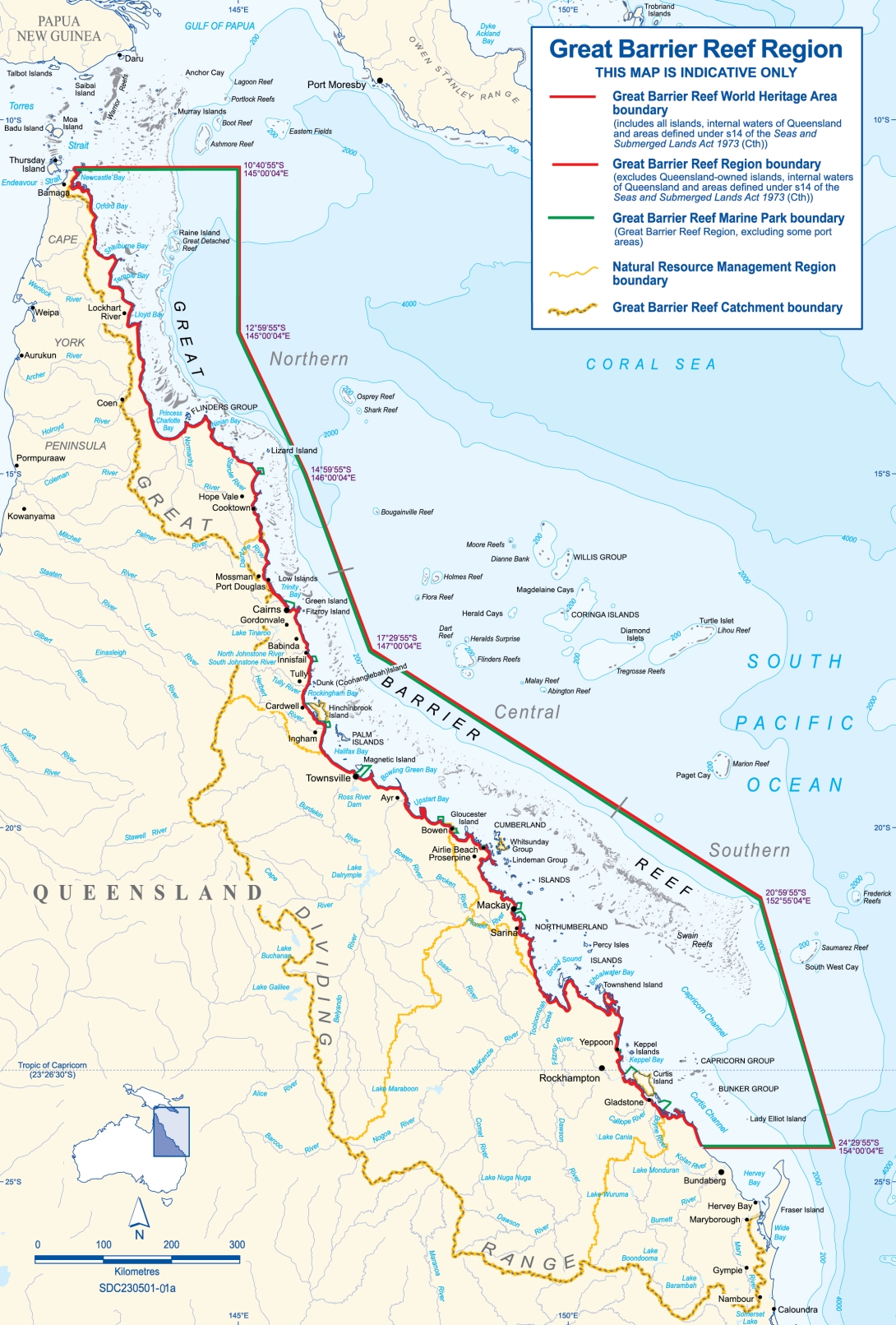
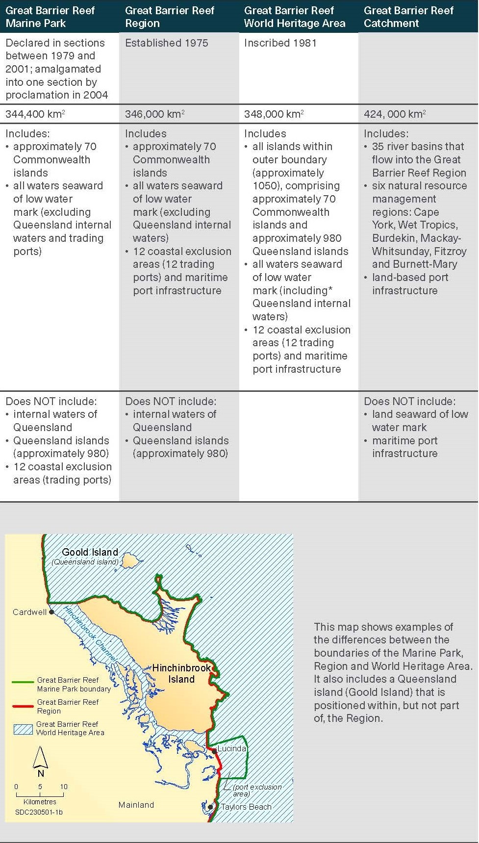
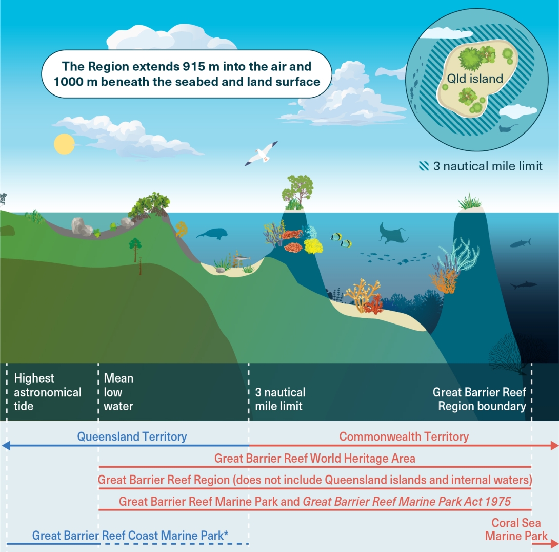
The jurisdictional scope of the report covers the entire Region (Figure 1.1). The Commonwealth has jurisdiction over most of the Region which covers approximately 346,000 square kilometres, from the tip of Cape York in the north to past Lady Elliot Island in the south.6 Mean low water is the landward boundary and it extends seaward at a distance between 70 and 250 kilometres to the eastern border with the Coral Sea Marine Park.6 It excludes the Torres Strait Region. The Region’s boundary is slightly larger than the Great Barrier Reef Marine Park (the Marine Park) and it includes the air above to a height of 915 metres, the subsoil beneath the surface of any land to a depth of 1000 metres, and about 70 Commonwealth Islands.7 The State of Queensland has jurisdiction over the majority of islands in the Reef (approximately 980 islands) which are, therefore, not included formally within the Region. However, where it is relevant to the health of, or factors influencing, the Reef ecosystem and its heritage values, the report looks beyond the Region’s jurisdictional boundaries and includes information about adjacent islands, neighbouring marine areas and the Great Barrier Reef river catchments (the Catchment). Jurisdictional differences between the various areas described in the report are outlined in Table 1.1 and Figure 1.2. Additional information on jurisdictions, governance arrangements and management responsibilities is provided in Section 7.1.1.
Figure 1.1
Great Barrier Reef Region and Catchment

Table 1.1
Differences between the Great Barrier Reef Marine Park, Region, World Heritage Area and Catchment
The square kilometres of each area is an approximation only. Terms relating to ports are described in Section 5.7.

The Outlook Report assesses all parts of the ecosystem within the Region, ranging from species and habitats to key ecosystem processes. For the purposes of the report, the ecosystem components within the Region are collectively referred to as the Great Barrier Reef ecosystem or simply the Great Barrier Reef. The report also assesses all aspects of the Region’s heritage values, including Indigenous and historic values and its world heritage value.
The Reef was inscribed on the World Heritage List in 1981 for all four natural criteria (Table 4.1). The assessment of the condition of the Region’s world heritage value, in Chapter 4, is directly informed by Chapters 2 and 3, which provide grades for a suite of natural heritage components. In addition, Appendix 3 presents a matrix describing how the components assessed in this report correspond with the attributes (outstanding features) that comprise the statement of outstanding universal value.
Figure 1.2
Jurisdictional boundaries
The Commonwealth and the State of Queensland have jurisdiction over various parts of the Region (red and blue lines, respectively). An intergovernmental agreement ensures integrated field management of the Great Barrier Reef Marine Park and the abutting Great Barrier Reef Coast Marine Park through joint management of marine parks and island national parks. The Queensland territory extends from the mainland to the three nautical mile limit. The Queensland territory includes Queensland-owned islands that lie within the Region, as well as the three nautical mile area surrounding Queensland-owned islands within the twelve nautical mile limit of the mainland (inset image).* The land boundary for the Great Barrier Reef Coast Marine Park may be high water or highest astronomical tide depending on location pursuant to the Marine Parks (Declaration) Regulation 2006. The dotted lines indicate the possible extent of the relevant legislation or jurisdiction (for example depending on species or fishery). Additional information on jurisdictions and management responsibilities is provided in the expanded version of this diagram in Section 7.1.1.

*This text has been updated subsequent to tabling of the Great Barrier Reef Outlook Report 2024.


