5.5.1 Current condition and trends of recreation

The Reef is enjoyed recreationally by Queensland’s coastal communities,1369 by other Australians 1370 and by the broader international community. Aside from commercial operations and tourism, people use the Region for a wide range of recreational activities, including relaxation, stress reduction through access to natural settings, and enjoyment through snorkelling, boating and diving. Recreational fishing, a major part of recreational activities, is considered in Section 5.4.

Quantifying and monitoring recreational use of the Reef in terms of numbers of people and locations is difficult and gaps remain in our understanding of trends. It is especially hard to distinguish recreation other than fishing from reported statistics that often include recreational fishing and sometimes tourism.

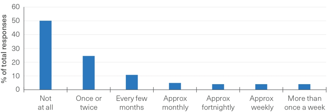
In a 2021 survey, 82 per cent of Region residents had visited the Reef at least once in their lifetime and 50 per cent had visited the Reef once in the previous 12 months for recreation.1075 Most residents (35.5 per cent) visit only once, twice or every few months. A smaller proportion (14 per cent) make more regular visits, either monthly, fortnightly, weekly or more than once a week (Figure 5.12).1075 Slightly more than 50 per cent of the residents who had already visited the Reef once in their lifetime reported that they would choose to visit the Reef over other places in their recreational time.1075 Residents place a high value on the socialising and lifestyle benefits provided by the Reef.1075 The most popular recreation activities in and around regional waterways include swimming, picnics and barbecues, wildlife watching and nature appreciation, exercising and fishing (recreational fishing is addressed in Section 5.4).1159

Figure 5.12
Residents’ frequency of visitation of the Reef for recreation in a 12-month period (2021)

Responses from 2488 residents. Source: Hobman et al. (2022)1075

This is a bar graph. The x-axis has 7 categories that show different groups of frequency visitation. The y-axis shows the percentage of survey respondents that answered each category.

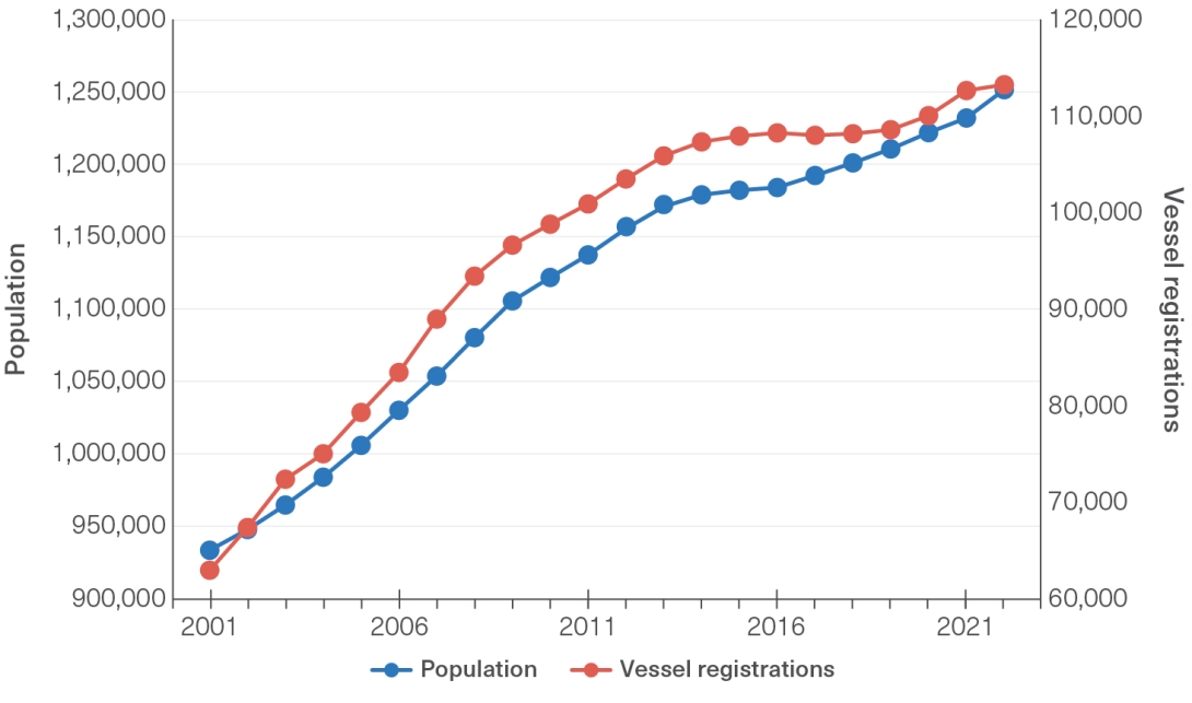
The number of recreational vessel registrations in 2018 to 2022 is the highest recorded and has increased in proportion to population growth in the Catchment (Figure 5.13). The impact of COVID-19 lockdowns and border restrictions on recreational use varied throughout the pandemic. Nationally, the ability to access to Reef depended on the proximity of residents to the Reef and different state health policies. Initially restrictions were placed on recreational boats accessing waters.1371 In Queensland, restrictions initially did not allow travel further than 50 kilometres from a person’s primary residence or fishing and boating except for obtaining food. As restrictions relaxed and travel resumed across the entire state, recreational boating provided an outlet for families and friends to connect with the Region. Border restrictions mostly stopped interstate and international boats and yachts from accessing the Region. From 2020 to 2021, people also diverged away from centralised workplaces and large population centres to regional areas, with the largest internal migration being to Queensland.1372,1373

Recreational use continues to grow in the Region

Figure 5.13
Number of recreational vessels registered and population in the Catchment, 2001 to 2022

Source: Queensland Department of Transport and Main Roads (2023),228 Australian Bureau of Statistics (2022)229

A line graph depicting that shows the total population in the Catchment and the number of vessel registrations in the Catchment from 2001–2022.

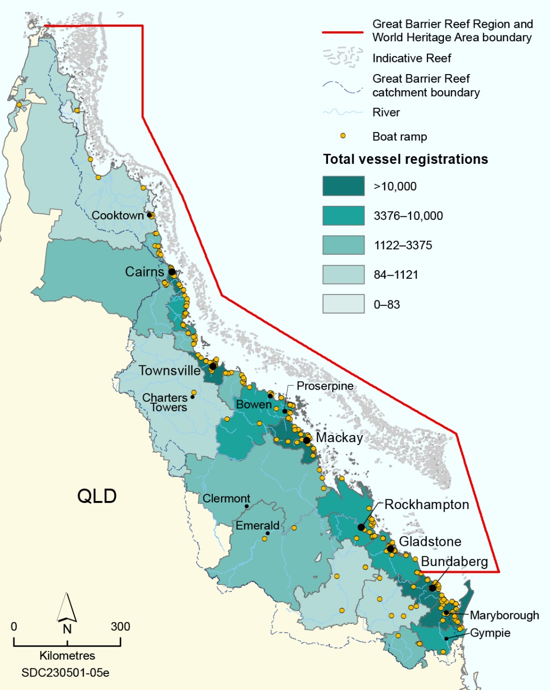
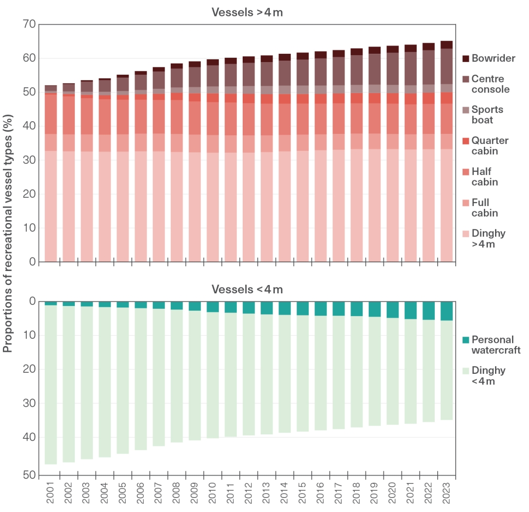
The Reef is accessed by large number and wide range of recreational users. Most recreational vessels registered in the Catchment are less than 5 metres in length, so recreational use is generally concentrated in inshore areas close to urban centres. The Cairns, Townsville, Mackay, Bundaberg and Fraser Coast (including Maryborough) local government areas have the highest numbers of boat registrations in the Catchment (Figure 5.14). Local residents spend a significant portion of their leisure time along the Reef coastline in coastal and inshore waterways, freshwater systems and estuaries.1075 However, 48 per cent of local residents surveyed also reported accessing offshore marine areas.1075 Marked increases in registrations of both small personal watercraft, such as jet skis, and larger vessels that can access mid- and outer-shelf reefs, indicate that local residents are accessing the Reef in different ways. The proportion of dinghies under 4 metres in length, however, has decreased (Figure 5.15). Population growth and economic development will continue to increase the demand for recreational activities within the Region (Section 6.2).

Figure 5.14
Recreational vessel registration per local government area and recreational boating facilities in the Catchment

Data as of June 2023. Source: Queensland Department of Transport and Main Roads (2023)1374,1376

A map of the Queensland coast with a line marking the Great Barrier Reef Region and World Heritage Area boundary. Along the coastline of Queensland are yellow dots to mark the locations of boat ramps. There are five coloured categories based on the total number of vessel registrations at various coastal local government areas.
Figure 5.15
Proportions of recreational vessel types registered, 2001 to 2023

Source: Queensland Department of Transport and Main Roads (2023)1374

There are two stacked bar graphs. The y-axis on both graphs is for the proportion (of the total vessel registration) of different vessel types and the x-axis on both graphs are years, ranging from 2001 to 2023. The top graph depicts vessels longer than 4 metres whilst the bottom graph depicts vessels under 4 metres.

Management | A number of Australian and Queensland government agencies and local government authorities are responsible for managing recreational use and/or the infrastructure that supports recreational use. Recreational use (not including fishing) is one of the major direct uses in the Region.1368 Recreational activities can be undertaken in almost all parts of the Region; exceptions are the Preservation Zones (which cover less than 2 per cent of the Marine Park) and Restricted Access Areas.

The zoning plans and plans of management for the Cairns, Hinchinbrook and Whitsundays areas protect the environment while providing for a range of uses. The plans of management cap the number of tourism operations, define maximum group and vessel sizes at specific locations, and define where motorised watersports can take place. These strategies were developed to protect the values of the Marine Park in high-use areas and to manage multiple uses, including recreational use. The Recreation Management Strategy for the Great Barrier Reef Marine Park (2012) provides an overarching framework for the management of recreation in the Marine Park.1368

A suite of responsible reef practices cover: anchoring and mooring (including use of public moorings); operating in the Region around turtles, whales and dolphins; bird watching; boating and yachting; collecting; diving and snorkelling; motorised watersports; outboard engines; visiting islands and cays; waste (including sewage); chemicals and litter; and accessing maritime heritage sites.1377

The Reef Joint Field Management Program provides and maintains infrastructure that supports recreational visitors, minimising the impacts to ecosystem values. Since 2019, for example, management initiatives have increased the number of reef protection markers, which show no-anchoring areas, and increased public moorings to a total of 1234 in the Region. Since 2019, an additional 60 moorings and 13 reef protection markers have been installed in the Whitsundays region, and 13 moorings and 4 reef protection markers within the North Tropical Coast region (from around Mission Beach to Cape Upstart). These management initiatives protect coral communities that are under threat from recreational boating damage, by raising awareness and influencing the distribution of recreational activities within the Region.1378 Campgrounds, boardwalks and walking tracks also provide for visitor experiences, improving community understanding of responsible reef practices and of the Region’s values and threats.

This program also improves community understanding of responsible reef practices and of the Region’s values and threats. For example, visitor experiences provided by campgrounds, boardwalks and walking tracks can improve community understanding. Other management initiatives under the Reef Joint Field Management Program to minimise impacts from recreational use include weed and pest management on islands.

Most vessel access to the Region is via public launch facilities (such as boat ramps) maintained by local and state governments. Existing infrastructure continues to be upgraded, and new infrastructure is being built, to keep up with demand for this ongoing direct use of the Region (Section 6.4.1). Recreational users have better access to learn about permitted activities in the Region via programs such as Reef Guardians and Eye on the Reef.

References
  • 228. Drew, E.A. and Abel, K.M. 1988, Studies on Halimeda: I. The distribution and species composition of Halimeda meadows throughout the Great Barrier Reef province, Coral Reefs 6: 195-205.
  • 229. Hillis-Colinvaux, L. 1980, Ecology and taxonomy of Halimeda: primary producer of coral reefs, in Advances in marine biology Elsevier, pp. 1-327.
  • 1075. Hobman, E. V., Mankad, A., Pert, P. L., van Putten, I., Fleming-Muñoz, D., Curnock, M. 2022, Monitoring social and economic indicators among residents of the Great Barrier Reef region in 2021: a report from the Social and Economic Long-term Monitoring Program (SELTMP) for the Great Barrier Reef, CSIRO Land and Water, Australia.
  • 1159. Curnock, M.I., Pert, P.L., Maharjan, D., Gordon, B. and Kaniewska, P. 2022, Design and implementation of social surveys for Regional Report Cards in the Great Barrier Reef catchment., CSIRO Land and Water, Townsville.
  • 1368. Great Barrier Reef Marine Park Authority 2012, Recreation management strategy for the Great Barrier Reef Marine Park, Great Barrier Reef Marine Park Authority, Townsville.
  • 1369. Larson, S., Stoeckl, N., Neil, B. and Welters, R. 2013, Using resident perceptions of values associated with the Australian tropical rivers to identify policy and management priorities, Ecological Economics 94: 9-18.
  • 1370. Goldberg, J., Marshall, N., Birtles, A., Case, P., Bohensky, E., et al. 2016, Climate change, the Great Barrier Reef and the response of Australians, Palgrave Communications 2(1): 1-8.
  • 1371. Cassidy, T. 2020, Coronavirus restrictions force recreational boaties and anglers off the water.
  • 1373. Australian Bureau of Statistics 2021, Population change in 2020, Commonwealth of Australia, <https://www.abs.gov.au/articles/population-change-2020#interstate-migration>.
  • 1374. Queensland Department of Transport and Main Roads 2023, Recreational vessel registration.
  • 1376. Queensland Department of Transport and Main Roads 2023, Recreational Boating Facilities Queensland, <https://www.data.qld.gov.au/dataset/recreational-boating-facilities-queensland>.
  • 1377. Great Barrier Reef Marine Park Authority 2022, Responsible Reef Practices , <https://www2.gbrmpa.gov.au/access/responsible-reef-practices>.
  • 1378. Mason, R.A.B., Bozec, Y. and Mumby, P.J. 2023, Setting sustainable limits on anchoring to improve the resilience of coral reefs, Marine Pollution Bulletin 189: 114721.